Toumba Architecture and Planning
Little is known about the settlement's architecture and planning during the MBA, due to the small size of the excavation targeted at this phase.
Older deposits, which belong to an open-air run with a few constructions, were found just below the top, at the edge of Toumba, indicating that the original construction took place on a natural elevation. Probably, a natural ditch at the base of Toumba was gradually filled with the waste of the habitation at the time.
The early phases of LBA constitute a period of special development for the settlement. The habitation was spread over several terraces located from the bottom up to the top of the site. On the highest terrace, parts of two buildings were discovered, "H" and "M", with a narrow road in between them, leading even higher. The walls were well built, with a high stone footing, well-made mudbricks, coated with fine clay. There were hearths and quadrilateral clay lined silos in the interior. There was probably a thin surrounding wall, on the base of the site, at the exterior.
At the end of this phase, all the settlement buildings were limited at the highest terraces of the site. In the middle of the slope, an impressive surrounding wall was built by means of a casemated wall system, which was created by a series of rectangular boxes, arranged one next to the other, along the contour lines of the mound . These boxes had a width of 6 m., an outer side height of around 3.20 m., and were filled with earth and building materials, thus creating a compact construction of significant dimensions, at least at the west and the south edges of the site. The foundation of the transverse walls of the boxes followed the inclination of the slope, but the top, along with the infill, created a wide flat surface, which was sometimes used for various outdoor activities. There was a road at the exterior that, possibly, led to the top through an opening. This system, which was no longer used in the late 10th century BC, served as a retaining wall for terraces of a higher level, delimited the settlement, and controlled access to it.
The excavation on the top of the site has revealed a part of the settlement from the period between 13th and early 10th century BC. Some fragmentary parts of the 6th and 5th century settlement were also detected in the same area.
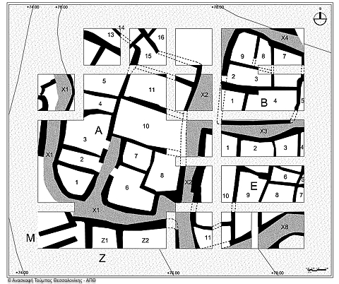
The architectural arrangement remained the same between 13th and 10th century BC. The settlement, in the excavated area, consists of large, rectangular, very densely constructed room units with narrow gravel roads in between. So far, three such room units were detected, complete or mostly complete, and small parts of at least other six.
The buildings of the settlement comprised a complex, consisting of multiple areas with or without a roof (courtyards, skylights). All buildings have been constructed with the same technique, i.e. stone foundations (out of rubble masonry) and brick superstructure. It seems that mudbricks were often made of the loam soil which surrounded the settlement.
So far, only building A has been excavated as a whole , its area covering approximately 200 m. Other buildings of the settlement, though not fully uncovered, do not seem to differ significantly in size, organization and construction.
In the interior of the buildings we found indications of various activities, such as food preparation (hearths, ovens, tools and food-processing facilities); textile production (spindle whorls and loom weights from vertical looms); fishing (shells, fish remains and net sinkers); metalworking (crucibles for melting metal and moulds for metal objects); processing of raw materials and tools (bone, stone and metal tools for woodworking, for the processing of leather, or stones and stone tools etc.) Furthermore, signs of storage (short-term and/or long-term) in storage jars, silos and plain pits, as well as in baskets, were located in all buildings.
The mudbrick walls of the buildings usually rested on low foundations and were reconstructed in the exact same place for at least three centuries. As a result, these reconstructions were sometimes kept and would reach a height of over 3m.
The phase of the 12th century B.C. is the most fully preserved and the one providing the greatest amount of information concerning the activities in the interior and the exterior of the buildings. Evidence from the 11th and 10th cent. phases during has been more or less destroyed by erosion and more recent interferences. It is clear, however, that throughout this time, the outer boundaries of the buildings remained more or less stable and that changes in the layout and the function of the spaces are observed only in the interior.
Despite the fact that some of the walls built in the archaic period rest exactly on walls dating back to the 11th and 10th centuries, the layout and organization of the buildings, as well as the building technique during 6th and 5th centuries B.C., appear to be much different, despite their bad maintenance. It is very probable that significant levelings took place, so that the buildings of this last period could be built. These levelings resulted in the destruction of the residential remains of the intermediate periods up to the 10th century and their disposal on the slope of the site.
The image of a radical reorganization of the settlement that took place during the 6th century B.C. also stems from the excavation data executed by the Ephorate of Antiquities of Thessaloniki City. Data were collected from the area around the base of the prehistoric mound where a great settlement, the trapeza, a settlement mound of trapezoidal form, was developed during historical times.


